Yorkshire Trip June 2013
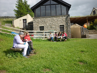
We had fantastic weather for our 4 day trip to the Yorkshire dales, round the National Park and coast. Our studies covered revision of river features, a fantastic introduction to Upland Limestone landscapes, urban study in the amazing city of York and a brief introduction to coastal processes and mass movement.
Everyone's favourite place was White Scar Caves where we found out that the ground under our feet is not always solid rock! Although there was a bit of walking and a step or two (or possibly a few more than that) everyone agreed that the effort was worth the view and the great feeling of achieving physical challenges.
Revision Websites
TOPICS TO BE COVERED (checklist!) :
PHYSICAL
Atmosphere:
1) You should be able to explain, using an appropriate diagram, why tropical latititudes receive more solar energy than polar regions.
2) You should be able to explain why there is a net gain of solar energy in the Tropical Latitudes and a Net Loss towards the Poles
3) You should be able to describe the distribution of the amount of solar energy which is absorbed by the Earth. This is known as the Earth's Heat Budget
4) You should be able to describe the factors which will affect the amount of sunlight reflected from the Earth's Surface
5) You must be able to describe the role of atmospheric circulation in the redistribution of energy over the globe. This is called 'Global Transfer of Energy' . You should be able to describe and explain how this happens using an appropriate diagram
7) You should be able to describe and explain the pattern of atmospheric circulation and global winds
8) You should be able to describe the main wind patterns throughout the Earth
9) You should be able to deescribe and explain the general pattern of ocean currents on a world map.
10) You should be able to describe variations in global temperatures fro the last 100 years as shown on a graph
11) You should be able to suggest both physical and human reasons for variations in global temperatures for the last 100-150 years.
12) You should be able to describe and explain the origin, nature and weather characteristics of Tropical Maritime and Tropical Continental air masses which affect West Africa.
13) You should know about inter-tropical convergence zones.
14) You should know the main features of the equatorial climate and savanna climate
15) You should know the effect of air masses and inter-tropical fronts on the equatorial and savanna climates
16) You should be able to describe and account for variations in West African rainfall with refrence to the Inter-Tropical Convergence Zones
Hydrosphere:
1) You should be able to both draw a diagram to show the global hydrological cycle and be able to describe the main elements of the diagram.
2) You should be able to explain how a balance is maintained within the hydrological cycle.
3) Using an O.S. map you should be able to describe the main characteristics of a river and its valley
4) You should be able to explain the formation of selected physical features of a river and its valley
5) You should be able to explain the effects of flowing water in relation to the processes of erosion, transportation and depostion in each of the three stages of a river valley.
6) You should be able to explain how soil water and groundwater storage varies according to changes in precipiation, evaporation, transpiration, infiltration and local geology.
7) You may be asked to complete a hydrograph by completing the key. You should therefore know the features of a hydrograph. You should also be able to describe and explain patterns on a river hydrograph.
8) You should be able to analyse hydrographs
10) You should be able to note the effects that changes to a drainage system, such as an increase in vegetation or steepness of slope or the presence of permeable or impermeable rock could have on different graphs.
Lithosphere
2) Erosion by glaciers produced several post-glacial landforms which you should be able to identify and describe their formation and characteristics.
3) You should be able to label a sketch to show features of glacial erosion and be able to explain how the landscape with these features was formed
4) You should be able to use an O.S. map to identify features of a glaciated landscape and comment on the relief and drainage pattern
5) You should be able to describe how an area has been affected by glacial erosion.
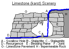
6) You should be able to describe and explain the processes that led to the formation of upland limestone (carboniferous) features. You should also be able to identify and label the main features of upland limestone areas on maps, sketches and aerial photographs.
7) You should be able to identify certain coastal landforms and explain how they were fromed including: cliffs, wave cut platforms, caves, arches, stacks, headlands, bays, spits, bars, longshore drift.
8) You should be able to describe and explain the processes involved in the modification of coastal landforms including attrition, corrasion, hydraulic action, longshore drift, sea level changes, slumping, rockfalls and cliff-line retreat.
9) You should know about the effects of sea level changes on coastlines
10) You should be able to identify the features of a glaciated landscape, upland limestone landscape and coastal features.
11) You should be able to use an O.S. map to provide evidence of change due to weathering and erosion.
12) You should be able to describe and explain the processes of weathering and erosion which have led to the formation of physical features in the landscape.
13) You should be able to describe and explain the conditions and processes which have led to the formation of rockfall, scree slopes and landslip espcecially as these affect coastlines.
14) You should be able to describe and explain the conditions and processes which have led to the formation of landslips / landslides and rockfall / scree
15) You should be able to use an O.S. map to describe and account for the relief of an area and the influence of physical factors on the drainage pattern.
16) You should be able to identify and annotate landscape features on a diagram.
17) You should be able to construct and interpret cross-sections and transects
Biosphere
1) You should be able to recognise and describe the properties of soils from a soil profile.
2) You should be able to describe and explain the effects of climate, relief and drainage on the formation of soils such as podzols, brown earth soils and gley / tundra soils.
3) You should be able to recognise and describe the properties of soils from a soil profile.
4) You should be able to describe and analyse soil profiles, particularly those of podzols, brown earth and gley / tundra profiles.
5) You should be able to explain the term 'ecosystem' and the processes which produce ecosystems on various scales for example from a pond to a forest area.
6) You should be able to explain fully what is meant by the term 'climax vegetation'
7) You should be able to describe an explain the process known as 'plant succession'
8) You should be able to describe and explain plant succession to be found across a sand dune transect, referring to the name of specific plants.
HUMAN
Population:
1) You should be able to interpret population pyramids for Economically More Developed Countries (EMDCs) and Economically Less Developed Countries (ELDCs) and account for the different structures
2) You should understand various terms relating to demographic trends
3) You must be able to describe and explain population structures and also describe and give reasons for any changes which may have taken place in populations of certain parts of the world.
4) With reference to population structures you should be able to discuss the problems that might arise from a rise in birth and death rates in developing countries and a fall in birth rates in developed countries
5)You should be able to compare different patterns of death by age group bewteen developed and developing countries, suggesting reasons for the differences
6) Referring to one or more stages within the Demographic Transition Model and specific case studies, you should be able to describe and explain factors which affect population growth and discuss factors affecting changes in birth and death rates.
7) You should know that population data is gathered through a census and that developing countries have more difficulties in carrying out a census than developed countries and the data is less reliable
8) You should be able to explain 'push and pull' factors of migration, both within a single country and bewteen two countries, and discuss factors which can create barriers to migration.
9) You should be able to discuss the advantages and disadvantages that migration has brought to both the losing and receiving countries
10) You should be familair with a variety of population graphs and be able to interpret them
Rural:
1) You should be able to describe the main features of the system of Shifting Cultivation and explain the population density associated with the system, and describe the main landscape features of this system
2) You should be able to describe changes in the system, discuss benefits and problems resulting from the changes and assess the impact of changes on people and their ways of life and the landscape.
3) You should be able to describe the main features of the system of Intensive Peasant Farming and explain the associated population density, and describe the main landscape features of this system
4) You should be able to describe changes in crop production and suggest why this has occurred , referring to, for example, the Green Revolution
5) You should be able to discuss the implications of these changes on people and th elandscape and comment on their success or otherwise.
6) You should be able to describe the system of Extensive Commercial Farming, describe its landscape and explain recent changes to the system and their effects.
7) You should be able to describe changes to ECF and comment on the benefits and problems caused by these changes
8) You should be able to describe and explain the settlement patterns which have resulted in this type of farming.
9) You should be able to describe and analyse land use data and crop yields shown in maps, diagrams and tables. you should be able to analyse farm survey results shown in tables. You should be able to annotate and analyse field sketches, photographs of rural landscapes and comment on the accuracy od statements based on various diagrams.
Industry:
1) You should know the different types of industry and be able to give examples of each type
2) You should be able to describe the main features of an industrial system
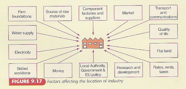
3) You should know the factors which influence the location of different types of industry (primary, secondary, tertiary - old and new industry). You should also be able to explain the impact of each factor on specific industries.
4) You should be able to describe the locational factors which help in attracting foreign manufacturing industries to an area.
5) Using an O.S. map you should be able to describe the main features of an industrial landscape. You may also be asked to use map evidence to explain the location of industry on the map.
6) With reference to an area you have studied, you should be able to describe and account for changes in an industrial area.
7) With reference to an industrial area you have studied, you should be able to refer to the factors which led to the growth of early industry, refer to any primary industry such as coal mining and explain why the area has gone into industrial decline.
8) You should be able to describe and account for recent indutrial change in your study area and the impact of this on the landscape and how industrial regeneration has affected the area.
9) You should be able to describe the environmental impact of new industrial develoments in your chosen area.
10) You should know various graphic techniques to be able to interpret graphs and diagrams based on industrial data.
Urban:
1) You should know the main factors that can affect the site of a town or city. You should refer to a case study of a named developed world city
2) Referring to a named city in the developed world, you should know how site and location affected its growth.
3) You should be able to describe the functional zones in a settlement giving map evidence to support your argument.
4) You should be able to describe and account for the location of functional zones within a town or city, from the CBD to the suburbs.
5) You should be able to identify the CBD of a settlement on an O.S. map, giving map evidence to support your choice. You should also be able to compare two CBDs, referring to their location and land use.
6) You should be able to describe the site and account for the location of particular zones within a town.
7) You should be able to describe and contrast the features of urban zones within a town or city and explain why the environment of particular zones are different.
8) You should be able to give map evidence to suggest the likely function of a settlement, e.g. resort or mining towns.
9) For a named city in the developed world you should be able to describe for the pattern of land uses within the CBD.
10) Referring to a named city in the developed world you should describe and account for changes which have occurred both within the CBD and inner city, explaining why they were necessary and comment on their relative success.
11) You should be able to describe the impacts of new developments, in particular, urban zones and be able to discuss any problems resulting from changes.
12) You should be able to describe and analyse land use maps, transects and survey data, e.g. land use maps from CBD to suburbs, and sphere of influence studies.
13) You should be able to annotate field sketches and photographs of urban areas and comment on the accuracy of statements describing urban patterns on maps and diagrams.
ENVIRONMENTAL INTERACTIONS
Health and Development:
1) You should be able to identify economic and social indicators of development and show how these can illustrate different levels of development of countries
2) You should be able to identify different levels of development from given resources such as a table or map and be able to suggest suitable socio-economic indicators which could be used to produce maps showing, for example, economically developed and less developed countries
3) You should be able to describe and account for similarities and differences on such maps and be able to describe the kind of indicators which would be appropriate to use in the construction of measures of development, e.g. Human Development Index
4) You should be able describe and explain differences in levels of development and explain the limits of some indicators such as GNP in accurately reflecting different levels of standard of living within any one country
5) You should know the factors which affect levels of malnutrition leading to a dowward spiral of poverty and poor health
6) You should be able to describe and explain differences in the provision of safe water and sanitation particularly between urban and rural areas.
7) You should be able to discuss the factors responsible for wide variations in life expectancy rates throughout the world.
8) You should be able to describe the human and physical factors which contribute to the spread of the disease and describe the methods used to control the disease and comment on their success.
9) You should explain the impact of lack of clean water and poor sanitation on disease rates and efforts to tackle and improve provision of clean water and better sanitation
10) You should be able to discuss the reasons for high infant mortality rates and the efforts to reduce these high rates and their effectiveness
11) You should know how primary healthcare methods are used to improve health standards and explain how disease prevention can benefit developing world countries.
Urban Change and Management:
1) Referring to named countries and cities: You should be able to describe and explain the changing patterns of city growth and explain different growth rates
2) You should be able to suggest reasons for increasing traffic congestion.
3) You should be able to describe and explain the distribution of cities in a given developed or developing country
4) You should be able to describe and explain variations in land use values within cities.
5) You should be able to determine the accuracy of statements relating to urban patterns as shown in a variety of maps and diagrams.
6) For a named city in the developed world you should be able to describe and explain the human and physical factors responsible for its growth
7) With reference to a named city you have studied in the developed world, you should be able to describe and explain the distribution of shopping centres.
8) Describe the ways in which problems such as industrial decline, poor housing and pollution have been tackled and comment on the effectiveness of the solution
9) You should be able to explain the factors causing traffic congestion and assess efforts to reduce traffic congestion
10) Describe and explain the problems related to the CBD and inner city areas and their solutions


